

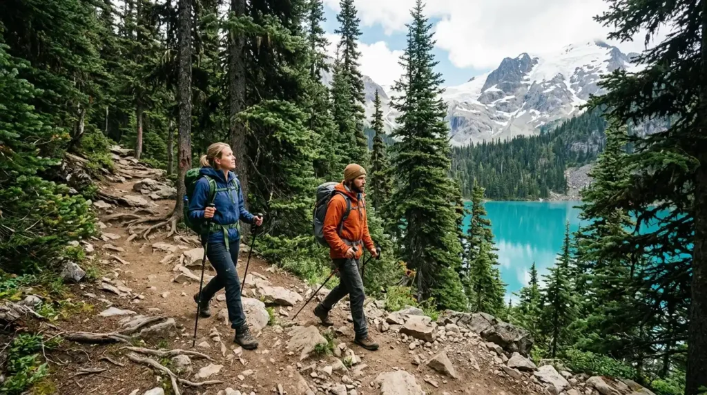
Joffre Lakes Provincial Park is one of British Columbia’s most recognizable alpine hikes, with three glacier-fed turquoise lakes beneath steep peaks and icefields. The scenery is easy to understand; the access rules require more planning. In 2026, day-use passes, scheduled closures, limited parking, and backcountry reservation rules can decide whether your trip works.
Direct answer: Joffre Lakes is a popular alpine day hike east of Pemberton, British Columbia. Expect about 10 km return and roughly 400 m of elevation gain to Upper Lake. During the 2026 peak season, most day visitors need a free pass booked two days in advance, and scheduled closures apply on certain dates.
| Trip detail | What to know in 2026 |
| Location | Off Highway 99 on Duffey Lake Road, east of Pemberton |
| Main route | Lower, Middle and Upper lakes |
| Distance | About 10 km return |
| Elevation gain | Approximately 400 m to Upper Lake |
| Typical outing | Allow roughly 4–6 hours, including stops |
| Day-use pass | Free; required May 11 to October 25, 2026 |
| Camping | Upper Lake only; advance reservation required |
| Dogs | Not permitted |
| Drinking water | Not provided |
| Cell service | Do not depend on having service |
Trail and visitor details are based on current BC Parks information and established regional trail guidance.
Key takeaways
- Reserve your free day-use pass two days before the hike, starting at 7 a.m. Pacific Time.
- Check the park advisory page before driving. A scheduled September closure affects part of the 2026 season.
- Bring your own drinking water and save your pass offline before leaving Pemberton.
- Leave pets at home, stay on marked routes, and use designated parking only.
Joffre Lakes Provincial Park passes and 2026 closures
BC Parks requires day-use trail passes from May 11 through October 25, 2026. Passes are free and become available online at 7 a.m. PT two days before your planned visit. Each person needs one, although children aged 12 or younger do not need a separate pass when accompanied by a parent or guardian with a valid pass. There is more on this in Things to Do in Kelowna.
The park is being managed for up to 500 day visitors per day during the pass period. One transaction can include up to four trail passes. Overnight campers with a valid camping reservation do not need a separate day-use pass.
For 2026, recreational closures were scheduled for June 20–27 and September 8–30. The September closure is still ahead as of this article’s August 29 update. The closures provide time for Lil’wat Nation and N’Quatqua cultural practices and support conservation goals.
Before leaving, use the official BC Parks day-use pass page and check current park advisories.
A simple 48-hour planning check can prevent a wasted drive:
- Confirm that the park is open on your date.
- Book the pass when the two-day window opens.
- Save or take a screenshot of the pass because service is limited.
- Check weather, road conditions, and your hiking gear.
For more trip-planning ideas across Canada, browse Lifevoria’s travel guides.
Where the park is and how to get there
The trailhead sits off Highway 99 east of Pemberton on Duffey Lake Road. Government information places the park about 35 kilometres east of Pemberton. Drivers coming from Vancouver commonly approach through the Sea-to-Sky corridor.
Parking is permitted only in designated lots. Do not park along Highway 99. BC Parks warns that roadside parking damages the area and is not permitted. Arriving with a pass also does not guarantee an informal roadside parking option.
Download anything you need before reaching the trailhead. BC Parks states that there is no cell service in the park.
What the hike is like
The route links Lower, Middle and Upper lakes in one out-and-back hike. Regional trail guidance lists the full trip at about 10 kilometres return. BC Parks reports approximately 400 metres of elevation gain between the parking area and Upper Lake.
Lower Lake is the easy introduction. BC Parks says its viewpoint is about a five-minute walk from the parking lot. The trail then climbs through hemlock and spruce forest before becoming steeper toward Middle Lake.
The final section toward Upper Lake becomes narrower and rougher. At the top, hikers reach views below Matier Glacier and Joffre Peak. BC Parks discourages scrambling higher because ice and rock can fall from the slopes above.
The Joffre Lakes trail is often described as intermediate rather than technical in normal summer conditions. Still, the elevation, mountain weather, rocky sections, and the return distance call for proper footwear and enough time.
When to visit
Summer is the most straightforward season for visitors seeking the classic hiking experience, but it is also the busiest. BC Parks describes the destination as busy seven days a week and especially crowded on weekends. If your dates are flexible, a weekday can reduce some parking and trail pressure. Always plan around the 2026 closure schedule rather than assuming early fall access is available.
Winter is a different trip. BC Parks warns of severe winter conditions from November through the end of May. Snow, ice, and avalanche exposure make winter recreation suitable for experienced and properly equipped visitors.
If you are comparing other Canadian destinations before setting your itinerary, you can also explore the broader Lifevoria travel section.
Camping at Upper Lake
Overnight camping is permitted only at Upper Joffre Lake Campground. The campground has 26 reservable tent pads, and reservations are required for overnight stays. Backcountry reservations can generally be made up to three months before arrival, beginning at 7 a.m. PT when the booking window opens.
For 2026, BC Parks lists base backcountry fees of $25 per night for adults aged 16 and older, $5 per night for youth aged 6–15, and no base fee for children under 6. Transaction fees also apply. BC Parks lists an additional $20 non-resident fee for visitors from outside British Columbia.
A camping reservation guarantees space, but it does not assign a specific tent pad. Campers choose an available pad after arrival. Campfires are permanently prohibited, so use an appropriate portable stove for cooking.
Safety rules and what to bring
This is a remote mountain park. BC Parks says there are no emergency services in the park and no drinking-water supply. Water taken from a lake or stream must be treated before drinking.
For a summer day hike, carry:
- Enough drinking water for your group
- Food and extra snacks
- Supportive hiking footwear
- Warm layers and a rain shell
- Sun protection and insect repellent
- Basic first-aid supplies
- An offline map and saved copy of your pass
Dogs and other domestic animals are not allowed. The lakes are glacier-fed and extremely cold, and BC Parks does not recommend swimming. There are no lifeguards. Visitors must also pack out their garbage.
Wildlife in the park includes black bears, grizzly bears, deer, and mountain goats. Campers should use the food-storage facilities provided at the campground.
Respecting Pipi7íyekw and its Indigenous significance
BC Parks identifies the area between North Joffre Creek and Cayoosh Pass as Pipi7íyekw, a St̓at̓imcets name meaning a camping place where storage houses were. The park lies within the unceded territories of the Lil’wat Nation and N’Quatqua.
That history provides important context for the scheduled cultural closures. Visitors should respect closure dates, remain on designated routes, avoid disturbing natural or cultural features, and follow Leave No Trace practices.
BC Parks increasingly uses the name Pipi7íyekw/Joffre Lakes Park in visitor information. Recognizing that name is part of understanding the place rather than treating the lakes only as a photo stop.
Plan the trip before you start the drive
The three turquoise lakes make this a memorable British Columbia outing, but preparation matters as much as the view. Secure the required pass, check closures, save your documents offline, bring enough water, and allow time for the full return hike.
Before your travel date, confirm the latest information directly with BC Parks because advisories can change. Then explore more destination and lifestyle ideas on Lifevoria and read how Lifevoria researches and updates its guides before planning your next Canadian trip.
Frequently asked questions
Yes, during the 2026 peak-season pass period. Day-use trail passes are required from May 11 through October 25. They are free and normally become available online two days before your visit at 7 a.m. PT. Campers with a valid overnight reservation do not need a separate day-use pass.
Plan roughly four to six hours for a relaxed day outing, including time at the lakes. Regional trail guidance lists about four hours of hiking for the approximately 10-kilometre return route. Your pace, rest stops, weather, and trail conditions can change the total.
BC Parks does not recommend it. The lakes are glacier-fed and extremely cold, with no lifeguards. A fall into cold water can become dangerous quickly, so treat the shoreline with care.
No. Dogs and other domestic animals are not permitted in the park. BC Parks says the restriction helps protect wildlife, fragile ecosystems, and the animals themselves.
Yes. Lower Lake is much easier to reach than the full alpine route. Its viewpoint is about five minutes from the parking area, according to BC Parks. Visitors still need to follow any day-pass requirements that apply on their date.